
Mooloolaba to University (M2U) Active Transport Corridor
Sunshine Coast Council is improving the active transport network for people walking, riding, pushing prams, using mobility aids, wheelchairs and scootering as well as for personal mobility devices, connecting the communities of Mooloolaba, Mountain Creek, Sippy Downs and Buderim.
The Mooloolaba to University (M2U) Active Transport Corridor project will create a safer and more connected, continuous 10 km active transport route between Mooloolaba and the UniSC.
The M2U Active Transport Corridor is located along the Queensland Government’s Principal Cycle Network (PCN). The M2U corridor is a high priority as it links many centres and schools to provide valuable and safe active transport connections for people walking, riding bikes, and using personal mobility devices.
It will connect schools, shopping centres, community facilities, future public transport infrastructure including the proposed WAVE Mountain Creek station, UniSC and TAFE Queensland Sunshine Coast, across Mooloolaba, Mountain Creek, Buderim, and Sippy Downs.
The M2U will cater for people of all ages, genders and abilities and improve safety, accessibility and connectivity for people walking, riding, pushing prams, using mobility aids, wheelchairs and scootering along this popular route. Upgrading the infrastructure along this corridor will help to improve the safety of people as they use the path, create slower speed environments within our streets, provide connectivity to key destinations including schools, shops and transport hubs and integrate with surrounding open space area.
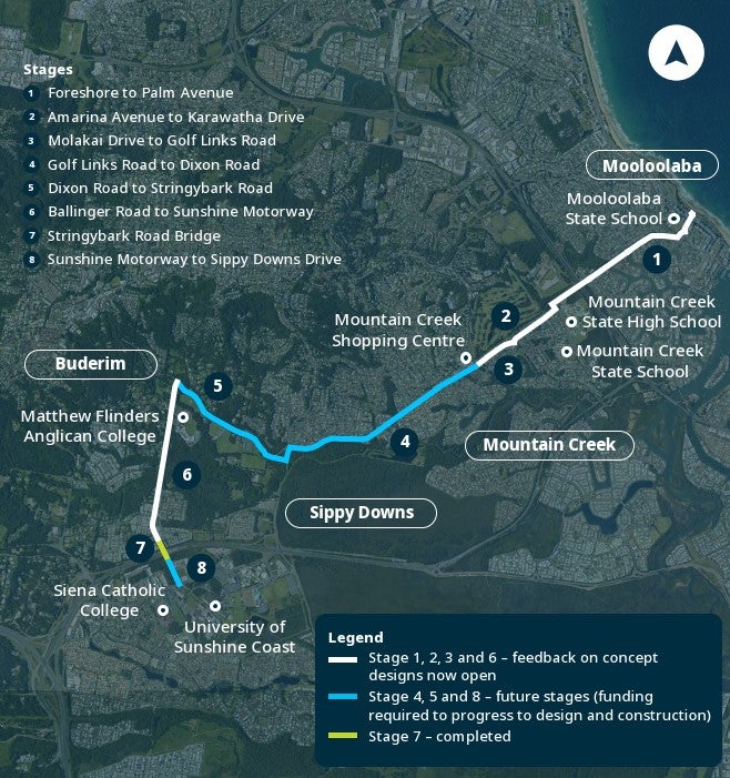
M2U will be delivered in stages (see below):
The proposed project route will link Mooloolaba and the UniSC.
Consultation now closed
Thank you to everyone who took part in the community engagement for the Mooloolaba to University (M2U) Active Transport Corridor.
Community consultation on the concept designs for Stages 1, 2, 3 and 6 has now closed. During Phase 2 engagement, held from 3 November to 5 December 2025, the community was invited to review the proposed designs and provide feedback on paths, crossings and other key project features.
The stages presented for feedback included:
- Stage 1 – Mooloolaba Foreshore to Palm Drive
- Stage 2 – Molakai Drive (from Amarina Avenue to Karawatha Drive with the link now focusing on Molakai Drive between Lady Musgrave Drive and the Karawatha Drive intersection due to the announcement of the Wave Metro, Stage 3)
- Stage 3 – Karawatha Drive (between Molakai Drive intersection and Golf Links Road roundabout)
- Stage 6 – Stringybark Road Active Transport link (between Ballinger Road roundabout and the Sunshine Motorway pedestrian bridge).
Thank you for taking the time to share your feedback. You can read more about the engagement and the engagement results on our Have your Say webpage.
Next steps
Stage 1 - Mooloolaba Foreshore to Palm Drive
Design work is continuing for Stage 1 and this is expected to be completed in late 2026.
Construction is planned to start in early 2027 and to be completed by 30 June 2027.
Stage 2 and 3
We are pleased to advise that the design has now been completed for:
- Stage 2: Molakai Drive, Mountain Creek (between Lady Musgrave Drive and the Karawatha Drive intersections)
- Stage 3: Karawatha Drive, Mountain Creek (between Molakai Drive intersection and Golf Links Road roundabout)
Following an extensive community engagement process, the project design has been refined to respond to community feedback while continuing to improve safety, accessibility and connectivity for people walking, riding, scootering, pushing prams and using mobility aids.
Many of the comments received during the design process helped shape the final outcome, including changes that retain the majority of on-street parking while delivering a safer and more accessible active transport corridor.
The project will now move into construction, with works currently planned to start in late 2026 and be completed by 30 June 2027, subject to weather and site conditions.
You can view the final design and information about the upcoming construction phase in the latest project news.
Stage 6 - Stringybark Road Active Transport link (Ballinger Road roundabout to Sunshine Motorway pedestrian bridge)
Design work is continuing for Stage 6 and is expected to be completed by June 2027. Further funding is required to progress this stage to the construction phase.
Stay updated
We will continue to keep our community informed as the project progresses and will provide further updates closer to the start of construction.
To stay updated on our active transport projects as they move into construction, including the M2U Active Transport Corridor, please subscribe below.
Funding
The Australian and Queensland governments are jointly contributing $3.8 million through the South East Queensland (SEQ) Liveability Fund, a commitment under the SEQ City Deal, towards Stages 1 and 2 of the Mooloolaba to University Active Transport Corridor. An additional $1.5 million in funding through the Queensland Government’s SEQ Community Stimulus Program will support the Karawatha Drive Active Transport link project, which is part of Stage 3.
Funding for Stage 6 Stringybark Road (Ballinger Road roundabout to Sunshine Motorway pedestrian bridge) is proudly supported by the Queensland Government’s Cycle Network Local Government Grants Program and is only for the design phase.
Background
Extensive community engagement has been an integral part of the M2U project.
Key highlights and themes which emerged from the community engagement for the M2U active transport corridor can be viewed on the Have your Say Sunshine Coast website.
Sunshine Coast Council’s Corporate Plan 2025-2030 includes ‘Our Strong Community’ goal. This encourages a healthy and active community through planning and delivery of the transport network to support active transport modes (walking and cycling).
To align with strategic priorities, the project will also reference Council’s Active Transport Plan. This considers development in the region, including population growth, the emergence of personal mobility devices, and improved active transport standards and guidelines.
Timeline
- 4 to 29 November 2024: Phase 1 Community Engagement
- November 2024 - September 2025: Development of design options
- 3 November - 5 December 2025: Phase 2 Community Engagement
- Early 2026: Detailed design
- Mid 2026: Phase 3 - Closing the feedback loop
- Stage 1: Final designs are expected to be completed by late 2026.
- Stage 2 and 3: Council presented the final designs in September 2026.
- Stage 6: Final designs are expected to be completed by June 2027.
- Late 2026: Implementation / construction (Stage 1, 2 and 3) Timing to be confirmed. Construction is planned to start in late 2026 and is scheduled for completion by 30 June 2027, subject to weather and site conditions.
- 2028: Implementation / construction (Stage 6). Construction funding is required to support project progression.
Frequently asked questions
What is active transport and why is it so important?
What is active transport and why is it so important?
Put simply, active transport incorporates people walking, riding, pushing prams, using mobility aids, wheelchairs and scootering, using e-bikes and other physically active ways of travelling that can be undertaken alone or combined with public transport.
All members of our community deserve to feel safe and welcome on our streets. An active transport corridor will ensure that more people can get around safely whether for recreation or commuting. Active transport will play a key role in Council creating a transport system that enables everyone in our community to access and enjoy our streets, while also supporting a healthy and sustainable future for our region.
Why is active transport important for the Sunshine Coast?
Council recognises the importance of making our streets safe and accessible for everyone. We know that our community love to go for a walk or a bike ride with family and friends, yet it is not always safe or possible to do so. Constructing an active transport corridor will help improve safety, accessibility and connectivity for people walking, riding, pushing prams, using mobility aids, wheelchairs and scootering through this popular neighbourhood. It will also support our community to enjoy healthy, sustainable and inclusive transport options.
This will also help us respond to the pressure of growth, support the liveability of the region, provide connectivity to important public transport hubs and achieve legacy outcomes from being a co-host city for the Brisbane 2032 Olympic and Paralympic Games.
When will this project be constructed?
When will this project be constructed?
Indicative timing (subject to weather and site conditions):
- Stage 1: Mooloolaba Foreshore to Palm Drive - Construction to start early 2027.
- Stage 2: Molakai Drive (Lady Musgrave Drive to Karawatha Drive intersection) - Construction to start late 2026.
- Stage 3: Karawatha Drive (Molokai Drive intersection to Golf Links Drive roundabout) - Construction to start late 2026.
Why is Council upgrading the path along Karawatha and Molakai Drive?
Why is Council upgrading the path along Karawatha and Molakai Drive?
The Mooloolaba to University (M2U) Active Transport Corridor will provide a safer, more connected route for people walking, riding, pushing prams, using mobility aids, wheelchairs and scootering between Mooloolaba, Mountain Creek, Sippy Downs and the UniSC precinct.
The project addresses missing links in the active transport network and improves safety and connectivity for people who use active transport to travel to schools, shopping centres, community facilities, future public transport infrastructure including the proposed WAVE Mountain Creek station, UniSC and TAFE Queensland Sunshine Coast.
What is a shared path?
What is a shared path?
A shared path is an off-road path designed to provide a safe option for people to walk, ride, push prams, use mobility aids, wheelchairs and scooters, that is separated from vehicle traffic.
All path users share the same space. New shared paths should generally be at least 3 metres (m) wide, with 2.5m as the absolute minimum standard. In some locations, site constraints such as power poles can require the width to be reduced to 2m.
What will the new shared path widths be in my street and why?
What will the new shared path widths be in my street and why?
- Karawatha Drive: approximately 3m wide.
- Molakai Drive: approximately 2.5m wide.
Following community feedback for Molakai Drive, we reassessed the original proposal of a 3m shared path on the southern side of the road against alternative path widths. Options considered included, retaining the existing 1.8m path as well as path widths of 2.25m, 2.4m and 2.5m.
A 2.5m shared path was selected for the following reasons:
- this width meets minimum standards for a shared path.
- provides additional space for path users to pass safely. Although path users have priority, this width assists the users to respond to vehicles entering or exiting a driveway
- this width met the minimum sightline standard at driveways for path users and vehicle drivers when calculated in accordance with State published guidelines
- supports school students and parents travelling together
- improves accessibility and is more inclusive of people using wheelchairs, mobility aids and pushing prams.
Why not extend the existing southern 1.8m path on Molakai Drive from the bus stop to Karawatha Drive?
Why not extend the existing southern 1.8m path on Molakai Drive from the bus stop to Karawatha Drive?
The existing 1.8 m path was constructed to meet the needs of the local area at that time.
The M2U Active Transport Corridor will create connectivity to schools, shopping centres, community facilities, future public transport infrastructure including the proposed WAVE Mountain Creek station, UniSC and TAFE Queensland Sunshine Coast.
Council is also planning for the future and the path is expected to be used by more people in the coming years.
What is the distance between my property and the edge of the new shared path?
What is the distance between my property and the edge of the new shared path?
The minimum distance from the property boundary to the edge of the new shared path will be:
- Molakai Drive: approximately 1m.
- Karawatha Drive: along Karawatha Drive, widening works have largely been accommodated within the road reserve while retaining most on-street parking. This has allowed the existing distance from the edge of the new path to the property boundary to remain approximately the same.
Can you move the shared path closer to the back of the kerb?
Can you move the shared path closer to the back of the kerb?
Council prefers to provide a minimum 1m distance from the roadside face of the kerb to the roadside edge of the path. This space provides:
- increased safety between people using the path and people getting in and out of vehicles
- support for shade trees to be planted
- a place for bins to be located on collection day.
Why is the shared path cutting through my driveway and what is the impact?
Why is the shared path cutting through my driveway and what is the impact?
The shared path will be constructed to continue through driveways and provide a clear, legible and accessible route. A continuous path surface helps to create driver awareness that they are crossing a shared path and that people using the shared path have priority.
This design is consistent with nearby sections of the M2U corridor, including Goonawarra Drive. During construction, there will be a short period when the driveway and path will not be accessible by vehicles.
Residents will be contacted in advance and we will work to minimise disruption wherever possible.
Will there be impact to on-street parking?
Will there be impact to on-street parking?
Throughout the design process, we heard strong community feedback about the importance of retaining on-street parking and we have refined the design to keep as much parking as possible in the final plans.
As a result, the majority of existing on-street parking will remain. Some parking restrictions are required near raised pedestrian crossings to maintain safe sightlines and allow vehicles and path users to move safely through these areas. Parking will be retained wherever it can be safely included, with any changes shown in attached design layouts.
We have made every effort to balance improved safety outcomes with the need to retain local parking while recognising the strategic importance of this active transport corridor.
Will the upgraded path benefit people using wheelchairs, mobility aids and prams?
Will the upgraded path benefit people using wheelchairs, mobility aids and prams?
Yes. A wider path provides a safer, more inclusive and accessible transport option for people of all ages, genders and abilities and make it easier for:
- wheelchair users
- mobility aid users
- people with prams
- people travelling together
- people travelling in opposite directions.
How does the design consider E-Bikes and E-Scooters on the shared path and around my driveway?
How does the design consider E-Bikes and E-Scooters on the shared path and around my driveway?
On all shared paths, e-bikes must keep to the signed speed limit (12km/h) and slow down to 12km/h when riding past a pedestrian.
From 1 July 2026, new speed limits apply to e-bikes and e-mobility devices traveling on footpaths and shared paths. Residents may contact the Queensland Police Service if there are speeding concerns.
There are not many people currently using the path. Why is the upgrade needed?
There are not many people currently using the path. Why is the upgrade needed?
Current path user numbers are only one factor considered when planning transport infrastructure. Experience across Australia shows that walking and riding demand is often influenced by the quality, safety and connectivity of available infrastructure.
Where facilities are narrow, disconnected or perceived as unsafe, many people choose not to use them. Council plans active transport projects to meet both current and future needs and to provide complete network connections.
Does the project connect to the future WAVE public transport project?
Does the project connect to the future WAVE public transport project?
Yes. The M2U corridor will provide a safer, more connected route for people walking, riding, pushing prams, using mobility aids and scootering to this proposed future public transport infrastructure and other key destinations.
Is Council removing the originally proposed separated cycleway from this design?
Is Council removing the originally proposed separated cycleway from this design?
The project design has evolved and been shaped by community feedback. We concluded that a shared path, combined with raised pedestrian crossing treatments, provides the best balance between safety, connectivity, local community considerations and the opportunity to retain parking along the corridor.
Are walking and riding counts used when planning projects?
Are walking and riding counts used when planning projects?
Yes. Traffic counts and user surveys are one of many tools used to inform planning and design decisions. However, infrastructure investment decisions are also influenced by broader factors including:
- network connectivity
- safety outcomes
- future growth
- school access
- public transport integration
- accessibility requirements.
Counts alone do not determine whether a project proceeds.
Why do we need raised pedestrian crossings in our streets?
Why do we need raised pedestrian crossings in our streets?
Raised pedestrian crossings encourage drivers to slow down where the shared path crosses the road. Lower vehicle speeds improve visibility, reinforce path user priority at designated crossings and reduce the likelihood and severity of collisions, creating a safer environment for people using the shared path.
Will the raised pedestrian crossings have lighting?
Yes. The raised pedestrian crossings will be positioned within the street-lighting network, and lighting levels will be assessed to ensure the raised pedestrian crossings and their users are adequately visible at night. Where needed, shields will be used on the lights to reduce light spill into nearby residential properties. Additional lighting upgrades will also occur along parts of Karawatha Drive where existing lighting does not meet current standards.
Will the raised pedestrian crossing be noisy?
Raised pedestrian crossings may create an increase in vehicle noise as tyres travel over the ramps. The raised pedestrian crossings in this project will be designed with lower heights and smoother ramps to minimise noise impacts whilst encouraging lower speeds and creating a safer environment for path users.
How does this project support travel to local schools?
How does this project support travel to local schools?
The shared path will provide a safer and more comfortable route for people travelling to and from school. School-age path users and parents often walk and ride to and from school together in groups.
A wider shared path allows these users to travel more safely and provides more inclusive active travel choices for families and students.
Why aren’t we building the path along the Energex easement?
Why aren’t we building the path along the Energex easement?
The shared path has been located within the road corridor of Karawatha Drive and Molakai Drive because it provides a safer, more direct and more accessible route.
A path beside the road benefits from better visibility, passive surveillance from passing road users and nearby residents, and easier access to homes, crossings and local destinations. It also allows users to conveniently access the path from multiple points along the street, rather than only at limited entry locations.
Locating the path within the Energex easement behind properties would create a more isolated environment, reduce visibility and personal security, limit future maintenance and emergency access, and could be affected by ongoing utility access requirements.
A path adjacent to the roadway is also generally easier for users to find, access and navigate, resulting in a safer and more attractive facility for the community.
Read through the latest Project News for the Mooloolaba to University Active Transport corridor below.
Project News: M2U Active Transport corridor
Project News: M2U Active Transport corridor
Contact us
Have a question for the project team? Get in touch via:
E: ActiveTransportLinks@sunshinecoast.qld.gov.au
P: 07 5475 7272 (stating below project numbers):
- P-H4624: Stage 1 - Mooloolaba Foreshore to Palm Drive
- P-K4250: Stage 2 - Molakai Drive, Mountain Creek
- P-H5955: Stage 3 - Karawatha Drive, Mountain Creek